New York State Department of Environmental Conservation
The NYS DEC regulates activities on or near the New York City shoreline, including tidal and freshwater wetland areas. Fees are required for Tidal Wetlands and Freshwater Wetlands permits.
Contact Information
 Permitting Inquiries
E: [email protected]
P: (718) 482-4997
F: (718) 482-4975
 Key Resources
- Region 2 Environmental Permits (including steps to take to determine jurisdiction)
- Tidal Wetlands Permit Program information
- Freshwater Wetlands Permit Program information
- DEC’s Waterfront Activities Application Checklist
- Application forms for DEC permits
Address
Regional Permit Administrator
New York State Department of Environmental Conservation
Region 2
1 Hunter’s Point Plaza
47-40 21st Street
Long Island City, NY 11101-5401
Working with the NYS DEC
- What to Know Before You Apply
You don’t need to know in advance all of the permits you need from the NYS DEC. They’ll determine that for you, based on the project information you provide. If you need more than one permit for your project, they may package the permits together and track them all under one core permit.
- Application Requirements and Fees
You must mail hard copies of the DEC’s Waterfront Activities Application Checklist (DEC to provide link); all required documents and drawings, as indicated on the checklist below; and one (1) digital copy (files in pdf format on a CD) of the entire submission to: Regional Permit Administrator, NYS DEC Region 2, 47-40 21st Street, Long Island City, NY 11101-5407.
For a general list of requirements, see: DEC’s Waterfront Activities Application Checklist
For a complete list of Joint Application requirements for all agencies, see: Joint Application Checklist
- What to Expect After You Apply
- Modifications, Transfers, and RenewalsMost projects have a permit duration of up to five years, but may be renewed, modified, and extended up to 10 years. Maintenance dredging projects have a permit duration of 10 years.
- Requests to renew, modify, or transfer a permit must be in writing to NYS DEC office in Long Island City.
- If you have an existing permit and wish to transfer it to someone else, you need to complete an Application for Permit Transfer form. The Application for Permit Transfer requires certification by both the proposed new owner/operator and the present permittee. Please allow 30 days for processing.
- If you are the new owner of property with an existing waterfront permit in place and are aware of any existing violations, there is a process for disclosing these to the NYS DEC. Please see the following for more information:
Waterfront Permits & Certifications
- Tidal Wetlands Permit
Tidal Wetlands permits are required for a range of activities on tidal wetlands and their adjacent areas.
Tidal wetlands are wetlands where tidal flooding occurs on a daily, monthly, or intermittent basis. For the purposes of NYS DEC permitting, tidal wetlands include the coastal shoreline as well as marshes, flats, shoals, bars, and all lands under tidal waters up to a depth of six feet at Mean Low Water (MLW). These areas are delineated on the New York State Tidal Wetland Inventory.
In New York City, a tidal wetland adjacent area may include any land area up to and within 150 feet from the tidal wetland boundary. Certain existing site conditions may limit the exact extent of the adjacent area.
- Freshwater Wetlands Permit
The NYS DEC Freshwater Wetlands Permit Program regulates a wide range of projects, work, and activities that occur in freshwater wetlands and their adjacent areas.
Freshwater wetlands
Lands and submerged lands that may have water visible for only part of the year, such as marshes, swamps, sloughs, bogs, and flats. They support aquatic or semi-aquatic vegetation and are valuable resources for flood control, surface and ground water protection, and wildlife habitat.
Freshwater wetland adjacent areas
Land or water areas that are outside the wetland, but within 100 feet of the wetland border (exceptions apply) that provide a valuable buffer to the wetland itself.
Where regulations apply
The DEC’s Freshwater Wetland Permit Program is limited to freshwater wetlands that appear on the New York State Fisheries Maps, and are at least 12.4 acres in size, or are designated as Unusual Local Importance (ULI) wetlands.
- Protection of Waters Permit
An NYS DEC Protection of Waters permit is required work or activity where there will be:
- Disturbance of Streams – Disturbance of a bed or banks of a protected stream, which includes water bodies in the course of a stream of 10 acres or less, with a classification of AA, A or B, or with a classification of C with a standard of (T) or (TS)
- Docks and Moorings – Construction, reconstruction and expansion of piers, wharfs, platforms, breakwaters, docking facilities, and the placement of moorings
- Excavation and Placement of Fill in Navigable Waters – Excavating or placing fill in any navigable waters of New York State, including ponds, lakes, rivers, and navigable streams with a classification and standard of C or D.
In addition to the water body or watercourse itself, adjacent and contiguous wetlands are also subject to permitting. However, a permit is not required for navigable waters that are totally surrounded by land held in a single private ownership.
Where regulations apply
Protection of Waters permitting applies to the following applications:
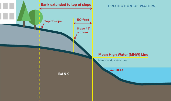
- Disturbance of Streams – Areas within the bed or banks of a protected stream, where a bank is not considered to extend more than 50 feet from mean high water or beyond top of a uniform angled slope; and a (stream) bed is land area covered by water at mean high water
- Docks and Moorings – Applies to dock and mooring structures on or above the navigable waters of the state (exceptions apply).
Excavation and Placement of Fill in Navigable Waters – Direct or indirect placement or excavation of fill in navigable waters of the state that are inundated at mean high water or mean high tide.
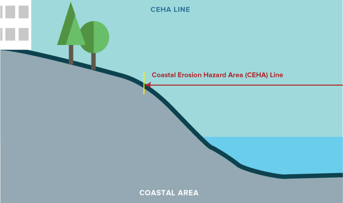
- Coastal Erosion Hazard Area Permit
A Coastal Erosion Hazard Area (CEHA) permit is required if activities near the shoreline are likely to impact one of two types of coastal erosion hazard areas:
CEHA Natural Protective Feature Areas (NPFA)
These are areas that contain the following natural features:
- Beaches
- Dunes
- Bluffs
- Nearshore areas
NPFAs protect natural habitats, infrastructure, structures, and human life from wind and water erosion, along with storm-induced high water. Human activities, such as the development or modification of beaches, dunes, or bluffs, may decrease or completely remove the erosion buffering function of natural protective features.
CEHA Structural Hazard
These are lands located landward of natural protective feature areas and have shoreline receding at a long-term average annual recession rate of one foot or more per year. Development within structural hazard areas is limited by regulation to reduce the risk to people and property from coastal erosion and flood damage.
Note: all actions that require a CEHA permit are presumed to be a SEQRA type 1 action
Where regulations apply
Due to the nature of the water’s edge, CEHA areas are constantly changing. Currently, CEHA areas exist in the following boroughs of New York City.
- Water Quality Certification
Water Quality Certification is required for:
Placing fill or undertaking activities resulting in a discharge to what the Army Corps refers to as Waters of the United States and where a permit is required from the Army Corps under Section 404 of the Clean Water Act.
Some examples of activities requiring a Water Quality Certification are:
- Activities that involve placement of dredged or fill materials in coastal or navigable waters
- Temporary discharges of decant waters from dredge material disposal sites or from barges and vessels
- Construction and operation of hydroelectric or major transmission facilities licensed by the federal government
- Related Permits
- Stormwater Permit for Construction Activity
- Water Withdrawals and Long Island Wells