Overview of Agency Jurisdiction
Federal, state and local agencies have different jurisdictions based on their mandates from underlying statutes, laws or regulations. Key boundaries or lines important to each agency are included on the infographics for the New York City Tidal Waterfront and Inland Waterways and Wetlands.
New York City Tidal Waterfront
See below for agency jurisdiction, permits, regulated areas and activities.
- U.S. Army Corps of Engineers
Regulated Areas
- Requires permits for all construction activity in navigable waters
- Requires permits for discharges of dredged or fill material, including excavation activities and placement of pilings
- Structures and work in tidal waters to Mean High Water (MHW)
- Discharges & dredging in tidal waters to Spring High Water (SHW)
- NYS Department of Environmental ConservationThere are four types of permits for work and activities impacting tidal wetlands, tidal waters, and adjacent areas.
- NYS Department of State
- Requires a federal consistency determination per the Coastal Management Program prior to issuance of any federal authorization or funding.
- NYS DOS has jurisdiction over any federal action within or affecting the coastal area of New York State.
- NYC Department of City Planning
- Oversees the NYC Waterfront Revitalization Program (WRP), reviewing applications for consistency with the WRP, and advising state agencies such as NYS DOS on waterfront projects.
- Administers the WRP in conjunction with the NYC Planning Commission, in its capacity as the City Coastal Commission.
- NYC Waterfront Revitalization Program covers the entire New York City shoreline
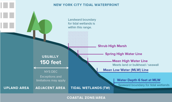
This graphic shows the approximate location (and relationships) of the water lines, boundaries, and geographical areas which feature most prominently in the regulation of New York City’s tidal waterfront. Terms are defined below.
Inland Waterways and Wetlands
See below for agency jurisdiction, permits, regulated areas and activities.
- U.S. Army Corps of Engineers
Regulates discharges of dredged or fill material into waters of the United States.
Jurisdiction over freshwater bodies to the Ordinary High Water Line (OHW) as well as any connected wetlands.
- NYS Department of Environmental Conservation
There are three types of permits for work and activities impacting freshwater wetlands, water bodies, and adjacent areas
- NYS Department of State
- A consistency determination from NYS DOS is necessary prior to the issuance of federal funding or authorization.
- Jurisdiction: Any federal action within or affecting the coastal area of New York State.
- NYC Department of City Planning
- Oversees the NYC Waterfront Revitalization Program (WRP), reviewing applications for consistency with the WRP, and advising state agencies such as NYS DOS on waterfront projects.
- Administers the WRP in conjunction with the NYC Planning Commission, in its capacity as the City Coastal Commission.
- NYC Waterfront Revitalization Program covers the entire New York City shoreline
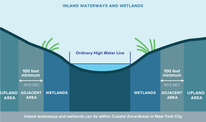
This graphic shows the approximate location (and relationships) of the geographical areas which feature most prominently in the regulation of New York City’s inland waterways and freshwater wetlands. Terms are defined below.
What does it mean?
Adjacent Area (AA)
Shall mean any land immediately adjacent to a tidal wetland within [certain limits, see 6 CRR-NY 661.4 for source text and diagrams].
Source: New York State Department of Environmental Conservation
Mean High Water (MHW)
Average height of the daily high waters over a 19-year period. For semidiurnal or mixed tides, the two high waters of each tidal day are included in the mean. For diurnal tides, the single daily high water is used to compute the mean.
Source: US Army Corps of Engineers, Low Cost Shore Protection: A Property Owner’s Guide, 2004
Mean Low Water (MLW)
Average height of the low waters over a 19-year period. For semidiurnal and mixed tides, the two low waters of each tidal day are included in the mean. For a diurnal tide, the one low water of each tidal day is used in the mean. Mean Low Water has been used as datum for many navigation charts published by the National Ocean Survey, but it is being phased out in favor of Mean Lower Low Water for all areas of the United States.
Source: US Army Corps of Engineers, Low Cost Shore Protection: A Property Owner’s Guide, 2004
Ordinary High Water Mark (OHWM)
The line on the shore in non‐tidal areas established by the fluctuations of water and indicated by physical characteristics such as a clear, natural line impressed on the bank, shelving, changes in the character of soil, destruction of terrestrial vegetation, the presence of litter and debris, or other appropriate means that consider the characteristics of the surrounding area.
Source: US Army Corps of Engineers New York District, Regulatory Program Applicant Information Guide, 2014
Spring High Water (SHW)
The average height of the high waters of the spring tides is called spring high water or mean high water springs (MHWS)
Source: NOAA Special Publication NOS CO-OPS 1, TIDAL DATUMS AND THEIR APPLICATIONS
Upland
Beyond the FEMA designated 100 year flood plain.
Source: New York State Department of Environmental Conservation, In-Water and Riparian Management of Sediment and Dredged Material, November 2004
Wetlands
Under the Clean Water Act, the term wetlands means “those areas that are inundated or saturated by surface or ground water at a frequency and duration sufficient to support, and that under normal circumstances do support, a prevalence of vegetation typically adapted for life in saturated soil conditions. Wetlands generally include swamps, marshes, bogs and similar areas.”
Source: New York State Department of Environmental Conservation, In-Water and Riparian Management of Sediment and Dredged Material, November 2004